Schömberg night lights from space
Night Light of Schömberg (Baden-Württemberg) from space (Germany) Src. Average luminocity for 10x10km area is 2.9077% and for 50x50km: 12.4063%.
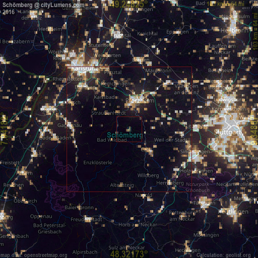
Analysis of Schömberg night lights 2016
Square area 10x10 km:
 0%
0%90-99
0%80-89
0%70-79
0%60-69
0.57%50-59
0%40-49
1.7%30-39
0.85%20-29
0.85%10-19
0%0-9
96.02%Square area 50x50 km:
1.17%90-99
1.83%80-89
1.02%70-79
1.31%60-69
1.7%50-59
1.77%40-49
1.81%30-39
2.25%20-29
3.07%10-19
11.46%0-9
72.61%Clear (daylight) street map image can be seen on geolist.org.
Map coordinates:
49° 14' 53.7" North, 7° 56' 30.6" East
48° 47' 13.7" North, 8° 38' 41.8" East
48° 19' 18.2" North, 9° 20' 53.1" East
Some cities around Schömberg sort by population:
• Pforzheim
11.5 km =7.1 mi,  20°
20°
• Calw
10.7 km =6.6 mi,  139°
139°
• Birkenfeld
8.9 km =5.5 mi,  354°
354°
• Bad Liebenzell
6.4 km =4 mi,  102°
102°
• Bad Wildbad
8 km =5 mi,  239°
239°
• Neuenbürg
7.4 km =4.6 mi,  330°
330°
• Tiefenbronn
12.2 km =7.6 mi,  70°
70°
• Neuhausen
9.7 km =6 mi,  86°
86°
2837115 (p: 8,725)
Sources (retrieved 2019-11-25):
» Earth at Night: Flat Maps 2012, 2016