Calw night lights from space
Night Light of Calw (Baden-Württemberg) from space (Germany) Src. Average luminocity for 10x10km area is 10.7753% and for 50x50km: 11.8513%.
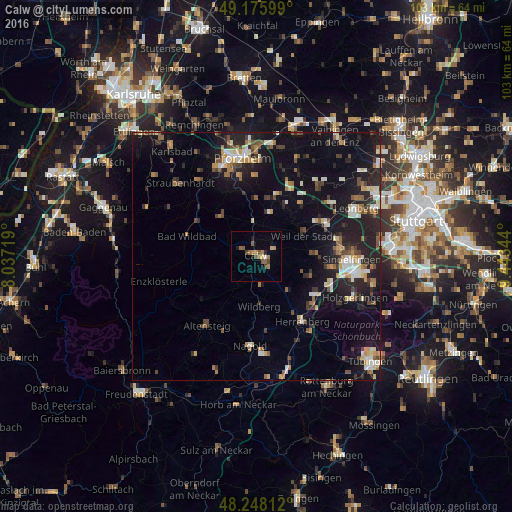

Analysis of Calw night lights 2016
Square area 10x10 km:
 0.45%
0.45%90-99
0.15%80-89
0.89%70-79
3.13%60-69
2.08%50-59
3.13%40-49
1.49%30-39
1.19%20-29
0.74%10-19
2.38%0-9
84.38%Square area 50x50 km:
1.15%90-99
1.86%80-89
0.99%70-79
1.29%60-69
1.47%50-59
1.59%40-49
1.66%30-39
1.53%20-29
4.3%10-19
10.92%0-9
73.25%Clear (daylight) street map image can be seen on geolist.org.
Map coordinates:
49° 10' 33.6" North, 8° 2' 13.9" East
48° 42' 51.1" North, 8° 44' 25.1" East
48° 14' 53.2" North, 9° 26' 36.4" East
Some cities around Calw sort by population:
• Weil der Stadt
10.4 km =6.5 mi,  67°
67°
• Wildberg
10.1 km =6.3 mi,  177°
177°
• Bad Liebenzell
6.7 km =4.2 mi,  353°
353°
• Aidlingen
12 km =7.5 mi,  109°
109°
• Schömberg
10.7 km =6.6 mi,  319°
319°
• Althengstett
4.1 km =2.5 mi,  75°
75°
• Neubulach
6.8 km =4.2 mi,  208°
208°
• Neuhausen
9.1 km =5.7 mi,  16°
16°
2940383 (p: 23,740)
Sources (retrieved 2019-11-25):
» Earth at Night: Flat Maps 2012, 2016