Tiefenbronn night lights from space
Night Light of Tiefenbronn (Baden-Württemberg) from space (Germany) Src. Average luminocity for 10x10km area is 15.6591% and for 50x50km: 17.3126%.
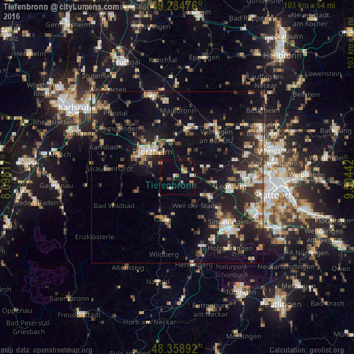
Analysis of Tiefenbronn night lights 2016
Square area 10x10 km:
 0.85%
0.85%90-99
3.13%80-89
0.99%70-79
1.56%60-69
3.41%50-59
1.28%40-49
1.42%30-39
1.85%20-29
2.41%10-19
7.24%0-9
75.85%Square area 50x50 km:
1.8%90-99
2.73%80-89
1.33%70-79
2.16%60-69
2.44%50-59
2.15%40-49
2.61%30-39
2.79%20-29
6.14%10-19
14.44%0-9
61.43%Clear (daylight) street map image can be seen on geolist.org.
Map coordinates:
49° 17' 5.1" North, 8° 5' 53.4" East
48° 49' 26.3" North, 8° 48' 4.6" East
48° 21' 32.1" North, 9° 30' 15.9" East
Some cities around Tiefenbronn sort by population:
• Pforzheim
10.1 km =6.3 mi,  311°
311°
• Weil der Stadt
9.8 km =6.1 mi,  148°
148°
• Niefern-Öschelbronn
10.4 km =6.5 mi,  352°
352°
• Bad Liebenzell
7.6 km =4.7 mi,  223°
223°
• Weissach
9.6 km =6 mi,  74°
74°
• Wiernsheim
7.5 km =4.7 mi,  28°
28°
• Neuhausen
3.9 km =2.4 mi,  207°
207°
• Heimsheim
5.2 km =3.2 mi,  111°
111°
2822401 (p: 5,583)
Sources (retrieved 2019-11-25):
» Earth at Night: Flat Maps 2012, 2016