Bad Liebenzell night lights from space
Night Light of Bad Liebenzell (Baden-Württemberg) from space (Germany) Src. Average luminocity for 10x10km area is 5.5398% and for 50x50km: 13.0587%.
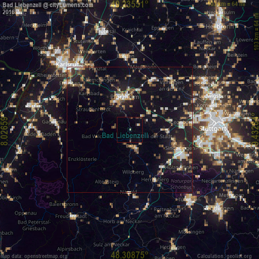
Analysis of Bad Liebenzell night lights 2016
Square area 10x10 km:
 0.57%
0.57%90-99
0%80-89
0.57%70-79
0.43%60-69
0.14%50-59
1.14%40-49
0.99%30-39
1.28%20-29
0.99%10-19
1.42%0-9
92.47%Square area 50x50 km:
1.2%90-99
1.83%80-89
1.03%70-79
1.44%60-69
1.69%50-59
1.77%40-49
1.93%30-39
1.96%20-29
4.71%10-19
12.43%0-9
70%Clear (daylight) street map image can be seen on geolist.org.
Map coordinates:
49° 14' 7.8" North, 8° 1' 35.7" East
48° 46' 27.4" North, 8° 43' 47" East
48° 18' 31.5" North, 9° 25' 58.2" East
Some cities around Bad Liebenzell sort by population:
• Pforzheim
12.4 km =7.7 mi,  349°
349°
• Calw
6.7 km =4.2 mi,  173°
173°
• Weil der Stadt
10.8 km =6.7 mi,  104°
104°
• Schömberg
6.4 km =4 mi,  282°
282°
• Althengstett
7.4 km =4.6 mi,  140°
140°
• Tiefenbronn
7.6 km =4.7 mi,  43°
43°
• Neuhausen
4 km =2.5 mi,  59°
59°
• Heimsheim
10.7 km =6.6 mi,  70°
70°
2953407 (p: 9,616)
Sources (retrieved 2019-11-25):
» Earth at Night: Flat Maps 2012, 2016