Johannisthal night lights from space
Night Light of Johannisthal (Berlin) from space (Germany) Src. Average luminocity for 10x10km area is 88.1301% and for 50x50km: 34.9396%.
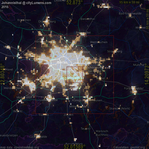
Analysis of Johannisthal night lights 2016
Square area 10x10 km:
 28.54%
90-99
30.56%80-89
15.78%70-79
12.25%60-69
6.44%50-59
4.04%40-49
2.4%30-39
0%20-29
0%10-19
0%0-9
0%Square area 50x50 km:
10.33%90-99
8.78%80-89
3.32%70-79
2.83%60-69
2.95%50-59
2.98%40-49
3.83%30-39
4.19%20-29
7.49%10-19
13.25%0-9
40.04%Clear (daylight) street map image can be seen on geolist.org.
Map coordinates:
52° 52' 22.8" North, 12° 48' 12.5" East
52° 26' 47.5" North, 13° 30' 23.8" East
52° 0' 57.2" North, 14° 12' 35" East
Some cities around Johannisthal sort by population:
• Rudow
2.9 km =1.8 mi,  210°
210°
• Buckow
3.5 km =2.2 mi,  242°
242°
• Gropiusstadt
3.6 km =2.2 mi,  228°
228°
• Altglienicke
4.4 km =2.7 mi,  153°
153°
• Oberschöneweide
1.9 km =1.2 mi,  31°
31°
• Baumschulenweg
2.6 km =1.6 mi,  325°
325°
• Adlershof
3.1 km =1.9 mi,  113°
113°
• Niederschöneweide
1.2 km =0.7 mi, 30°
2894755 (p: 18,254)
Sources (retrieved 2019-11-25):
» Earth at Night: Flat Maps 2012, 2016