Adlershof night lights from space
Night Light of Adlershof (Berlin) from space (Germany) Src. Average luminocity for 10x10km area is 75.8611% and for 50x50km: 33.6892%.
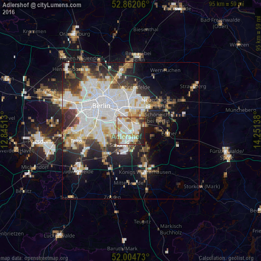
Analysis of Adlershof night lights 2016
Square area 10x10 km:
 19.07%
90-99
26.64%80-89
11.99%70-79
10.73%60-69
5.81%50-59
5.56%40-49
4.29%30-39
4.67%20-29
8.46%10-19
2.78%0-9
0%Square area 50x50 km:
10.3%90-99
8.6%80-89
3.18%70-79
2.83%60-69
2.74%50-59
2.89%40-49
3.63%30-39
4.1%20-29
6.41%10-19
10.88%0-9
44.43%Clear (daylight) street map image can be seen on geolist.org.
Map coordinates:
52° 51' 43.4" North, 12° 50' 42.5" East
52° 26' 7.7" North, 13° 32' 53.7" East
52° 0' 17" North, 14° 15' 5" East
Some cities around Adlershof sort by population:
• Köpenick
2.1 km =1.3 mi,  57°
57°
• Berlin Köpenick
2.4 km =1.5 mi,  71°
71°
• Rudow
4.5 km =2.8 mi,  253°
253°
• Altglienicke
2.8 km =1.7 mi,  197°
197°
• Oberschöneweide
3.4 km =2.1 mi,  327°
327°
• Johannisthal
3.1 km =1.9 mi,  293°
293°
• Niederschöneweide
3.2 km =2 mi,  315°
315°
• Grünau
3 km =1.9 mi,  134°
134°
2959441 (p: 15,294)
Sources (retrieved 2019-11-25):
» Earth at Night: Flat Maps 2012, 2016