Schleiz night lights from space
Night Light of Schleiz (Thuringia) from space (Germany) Src. Average luminocity for 10x10km area is 2.1791% and for 50x50km: 1.7813%.
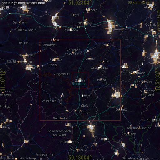
Analysis of Schleiz night lights 2016
Square area 10x10 km:
 0.8%
0.8%90-99
0.27%80-89
0%70-79
0%60-69
0.13%50-59
0.94%40-49
0.53%30-39
0%20-29
0%10-19
0%0-9
97.33%Square area 50x50 km:
0.24%90-99
0.23%80-89
0.27%70-79
0.26%60-69
0.19%50-59
0.2%40-49
0.28%30-39
0.22%20-29
0.22%10-19
0.91%0-9
96.97%Clear (daylight) street map image can be seen on geolist.org.
Map coordinates:
51° 1' 22.9" North, 11° 6' 25.6" East
50° 34' 43.2" North, 11° 48' 36.9" East
50° 7' 48.1" North, 12° 30' 48.1" East
Some cities around Schleiz sort by population:
• Plauen
24.9 km =15.5 mi,  111°
111°
• Zeulenroda
14.8 km =9.2 mi,  56°
56°
• Pößneck
20 km =12.4 mi,  309°
309°
• Weida
28 km =17.4 mi,  38°
38°
• Naila
28.6 km =17.8 mi,  195°
195°
• Neustadt an der Orla
18.1 km =11.2 mi,  345°
345°
• Bad Lobenstein
18.5 km =11.5 mi,  220°
220°
• Elsterberg
25.5 km =15.8 mi,  82°
82°
2838673 (p: 8,976)
Sources (retrieved 2019-11-25):
» Earth at Night: Flat Maps 2012, 2016