Illingen night lights from space
Night Light of Illingen (Saarland) from space (Germany) Src. Average luminocity for 10x10km area is 11.5495% and for 50x50km: 15.7299%.
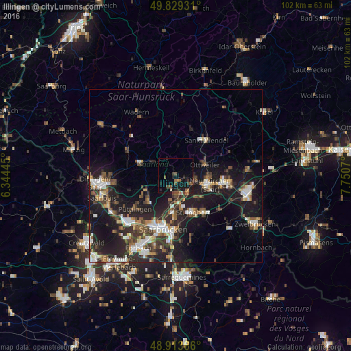
Analysis of Illingen night lights 2016
Square area 10x10 km:
 0%
0%90-99
0.8%80-89
0.4%70-79
1.47%60-69
1.74%50-59
3.07%40-49
2.27%30-39
2.01%20-29
3.21%10-19
15.37%0-9
69.65%Square area 50x50 km:
2.19%90-99
2.48%80-89
1.21%70-79
1.48%60-69
1.63%50-59
2.24%40-49
2.67%30-39
3.04%20-29
6.04%10-19
15.08%0-9
61.95%Clear (daylight) street map image can be seen on geolist.org.
Map coordinates:
49° 49' 45.5" North, 6° 20' 40" East
49° 22' 25" North, 7° 2' 51.3" East
48° 54' 49.2" North, 7° 45' 2.5" East
Some cities around Illingen sort by population:
• Sulzbach
8.3 km =5.2 mi,  175°
175°
• Eppelborn
6.5 km =4 mi,  296°
296°
• Schiffweiler
6.3 km =3.9 mi,  97°
97°
• Spiesen-Elversberg
8.9 km =5.5 mi,  135°
135°
• Quierschied
6.3 km =3.9 mi, 178°
• Friedrichsthal
6.2 km =3.9 mi,  145°
145°
• Marpingen
8.8 km =5.5 mi,  5°
5°
• Merchweiler
2.6 km =1.6 mi, 176°
2896538 (p: 18,488)
Sources (retrieved 2019-11-25):
» Earth at Night: Flat Maps 2012, 2016