Friedrichsthal night lights from space
Night Light of Friedrichsthal (Saarland) from space (Germany) Src. Average luminocity for 10x10km area is 32.3008% and for 50x50km: 16.9229%.
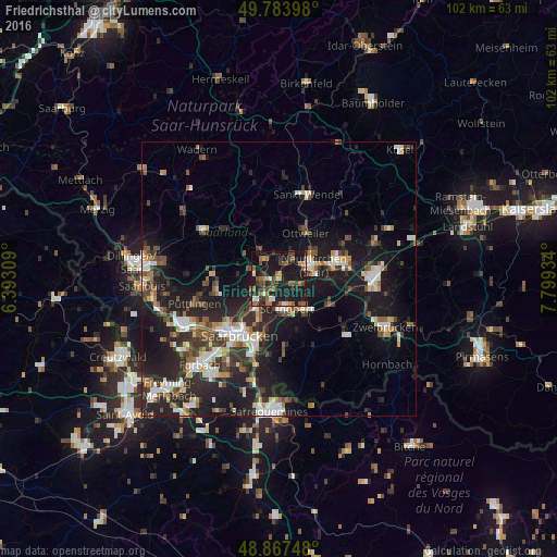
Analysis of Friedrichsthal night lights 2016
Square area 10x10 km:
 1.2%
1.2%90-99
3.61%80-89
2.01%70-79
2.94%60-69
7.09%50-59
7.89%40-49
6.55%30-39
7.89%20-29
13.64%10-19
39.3%0-9
7.89%Square area 50x50 km:
2.39%90-99
2.6%80-89
1.39%70-79
1.58%60-69
1.83%50-59
2.3%40-49
2.79%30-39
3.16%20-29
6.97%10-19
15.71%0-9
59.28%Clear (daylight) street map image can be seen on geolist.org.
Map coordinates:
49° 47' 2.3" North, 6° 23' 35.1" East
49° 19' 40.3" North, 7° 5' 46.4" East
48° 52' 2.9" North, 7° 47' 57.6" East
Some cities around Friedrichsthal sort by population:
• Neunkirchen
6.4 km =4 mi,  73°
73°
• Sankt Ingbert
5.9 km =3.7 mi,  165°
165°
• Illingen
6.2 km =3.9 mi,  325°
325°
• Sulzbach
4.3 km =2.7 mi,  221°
221°
• Schiffweiler
5.1 km =3.2 mi,  31°
31°
• Spiesen-Elversberg
3 km =1.9 mi,  114°
114°
• Quierschied
3.6 km =2.2 mi,  249°
249°
• Merchweiler
4.2 km =2.6 mi,  306°
306°
2924461 (p: 11,440)
Sources (retrieved 2019-11-25):
» Earth at Night: Flat Maps 2012, 2016