Quierschied night lights from space
Night Light of Quierschied (Saarland) from space (Germany) Src. Average luminocity for 10x10km area is 31.754% and for 50x50km: 19.0002%.
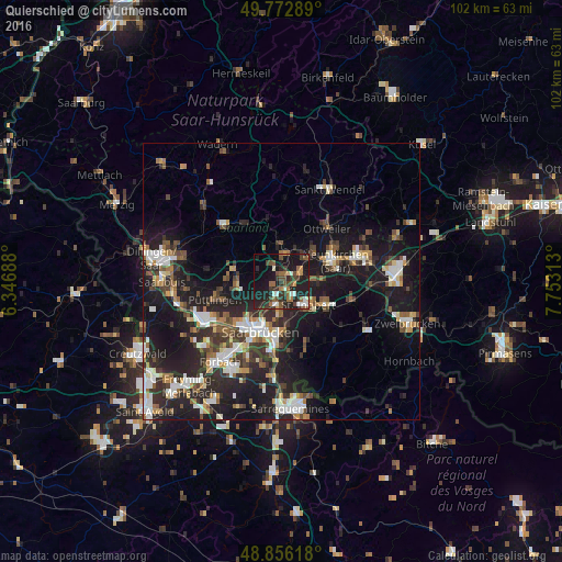
Analysis of Quierschied night lights 2016
Square area 10x10 km:
 2.81%
2.81%90-99
4.68%80-89
1.07%70-79
2.54%60-69
5.88%50-59
5.75%40-49
6.42%30-39
8.16%20-29
17.78%10-19
30.75%0-9
14.17%Square area 50x50 km:
2.92%90-99
3.14%80-89
1.44%70-79
1.76%60-69
2.06%50-59
2.44%40-49
2.98%30-39
3.45%20-29
7.7%10-19
17.92%0-9
54.19%Clear (daylight) street map image can be seen on geolist.org.
Map coordinates:
49° 46' 22.4" North, 6° 20' 48.8" East
49° 19' 0" North, 7° 3' 0" East
48° 51' 22.2" North, 7° 45' 11.3" East
Some cities around Quierschied sort by population:
• Sankt Ingbert
6.5 km =4 mi,  132°
132°
• Illingen
6.3 km =3.9 mi,  358°
358°
• Sulzbach
2 km =1.2 mi,  165°
165°
• Schiffweiler
8.2 km =5.1 mi,  47°
47°
• Riegelsberg
8.7 km =5.4 mi,  257°
257°
• Spiesen-Elversberg
6 km =3.7 mi,  90°
90°
• Friedrichsthal
3.6 km =2.2 mi,  69°
69°
• Merchweiler
3.7 km =2.3 mi,  0°
0°
2851337 (p: 14,545)
Sources (retrieved 2019-11-25):
» Earth at Night: Flat Maps 2012, 2016