Reichertshofen night lights from space
Night Light of Reichertshofen (Bavaria) from space (Germany) Src. Average luminocity for 10x10km area is 5.6116% and for 50x50km: 5.8647%.
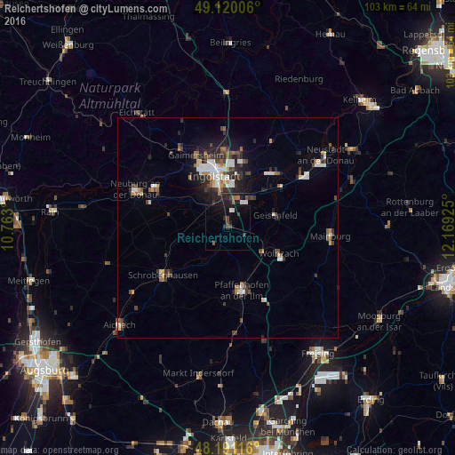
Analysis of Reichertshofen night lights 2016
Square area 10x10 km:
 0.74%
0.74%90-99
0.45%80-89
0%70-79
0%60-69
0%50-59
0.6%40-49
2.08%30-39
1.93%20-29
0.74%10-19
4.46%0-9
88.99%Square area 50x50 km:
0.92%90-99
0.96%80-89
0.42%70-79
0.36%60-69
0.62%50-59
0.77%40-49
1.14%30-39
0.99%20-29
1.74%10-19
2.88%0-9
89.2%Clear (daylight) street map image can be seen on geolist.org.
Map coordinates:
49° 7' 12.2" North, 10° 45' 46.8" East
48° 39' 27.9" North, 11° 27' 58" East
48° 11' 28.2" North, 12° 10' 9.3" East
Some cities around Reichertshofen sort by population:
• Ingolstadt
12.3 km =7.6 mi,  345°
345°
• Pfaffenhofen an der Ilm
14.4 km =8.9 mi,  168°
168°
• Manching
6.9 km =4.3 mi,  17°
17°
• Wolnzach
13.2 km =8.2 mi,  117°
117°
• Geisenfeld
11.1 km =6.9 mi,  74°
74°
• Vohburg an der Donau
16.7 km =10.4 mi,  41°
41°
• Rohrbach
8.7 km =5.4 mi, 121°
• Karlshuld
13.6 km =8.5 mi,  281°
281°
2849017 (p: 7,298)
Sources (retrieved 2019-11-25):
» Earth at Night: Flat Maps 2012, 2016