Manching night lights from space
Night Light of Manching (Bavaria) from space (Germany) Src. Average luminocity for 10x10km area is 24.1548% and for 50x50km: 5.7049%.
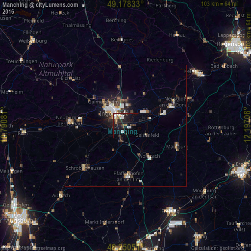
Analysis of Manching night lights 2016
Square area 10x10 km:
 5.21%
5.21%90-99
3.87%80-89
1.34%70-79
1.19%60-69
2.83%50-59
2.53%40-49
2.53%30-39
4.17%20-29
9.08%10-19
23.21%0-9
44.05%Square area 50x50 km:
0.91%90-99
0.94%80-89
0.39%70-79
0.38%60-69
0.62%50-59
0.72%40-49
1.1%30-39
0.96%20-29
1.69%10-19
2.89%0-9
89.41%Clear (daylight) street map image can be seen on geolist.org.
Map coordinates:
49° 10' 42" North, 10° 47' 26.9" East
48° 42' 59.6" North, 11° 29' 38.1" East
48° 15' 1.8" North, 12° 11' 49.4" East
Some cities around Manching sort by population:
• Ingolstadt
7.5 km =4.7 mi,  316°
316°
• Wolnzach
15.8 km =9.8 mi,  142°
142°
• Gaimersheim
13.7 km =8.5 mi, 317°
• Geisenfeld
9.4 km =5.8 mi,  112°
112°
• Reichertshofen
6.9 km =4.3 mi,  197°
197°
• Vohburg an der Donau
10.9 km =6.8 mi,  57°
57°
• Rohrbach
12.3 km =7.6 mi,  154°
154°
• Karlshuld
15.8 km =9.8 mi,  255°
255°
2873992 (p: 11,239)
Sources (retrieved 2019-11-25):
» Earth at Night: Flat Maps 2012, 2016