Radeburg night lights from space
Night Light of Radeburg (Saxony) from space (Germany) Src. Average luminocity for 10x10km area is 4.6373% and for 50x50km: 9.272%.
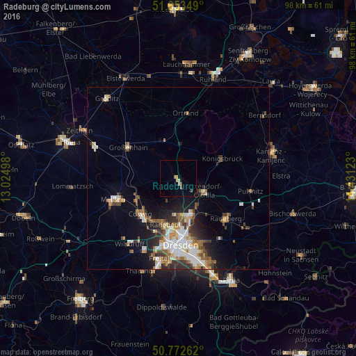
Analysis of Radeburg night lights 2016
Square area 10x10 km:
 0.56%
0.56%90-99
0%80-89
0.56%70-79
1.54%60-69
0.28%50-59
0.98%40-49
0.56%30-39
0%20-29
0%10-19
0.42%0-9
95.1%Square area 50x50 km:
1.71%90-99
1.87%80-89
0.72%70-79
1.13%60-69
1.11%50-59
1.33%40-49
1.24%30-39
1.42%20-29
1.72%10-19
4.24%0-9
83.5%Clear (daylight) street map image can be seen on geolist.org.
Map coordinates:
51° 39' 12.6" North, 13° 1' 29.9" East
51° 12' 54.6" North, 13° 43' 41.2" East
50° 46' 21.4" North, 14° 25' 52.4" East
Some cities around Radeburg sort by population:
• Dresden
18.3 km =11.4 mi,  177°
177°
• Meissen
18.7 km =11.6 mi,  251°
251°
• Coswig
13.7 km =8.5 mi,  227°
227°
• Großenhain
15.9 km =9.9 mi,  301°
301°
• Weinböhla
12.5 km =7.8 mi,  244°
244°
• Ottendorf-Okrilla
8.1 km =5 mi,  115°
115°
• Moritzburg
7.1 km =4.4 mi,  208°
208°
• Ebersbach
5.8 km =3.6 mi,  290°
290°
2851074 (p: 7,812)
Sources (retrieved 2019-11-25):
» Earth at Night: Flat Maps 2012, 2016