Ebersbach night lights from space
Night Light of Ebersbach (Saxony) from space (Germany) Src. Average luminocity for 10x10km area is 0.6373% and for 50x50km: 8.7521%.
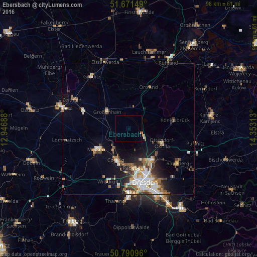
Analysis of Ebersbach night lights 2016
Square area 10x10 km:
 0%
0%90-99
0%80-89
0%70-79
0.42%60-69
0.14%50-59
0%40-49
0%30-39
0%20-29
0%10-19
0%0-9
99.44%Square area 50x50 km:
1.62%90-99
1.71%80-89
0.68%70-79
1.09%60-69
1.07%50-59
1.28%40-49
1.13%30-39
1.17%20-29
1.47%10-19
4.03%0-9
84.75%Clear (daylight) street map image can be seen on geolist.org.
Map coordinates:
51° 40' 17.4" North, 12° 56' 48.8" East
51° 13' 60" North, 13° 39' 0" East
50° 47' 27.5" North, 14° 21' 11.3" East
Some cities around Ebersbach sort by population:
• Radebeul
14.1 km =8.8 mi,  177°
177°
• Meissen
14.6 km =9.1 mi,  236°
236°
• Coswig
12.2 km =7.6 mi,  202°
202°
• Großenhain
10.2 km =6.3 mi,  307°
307°
• Weinböhla
9.4 km =5.8 mi,  218°
218°
• Ottendorf-Okrilla
13.9 km =8.6 mi,  113°
113°
• Moritzburg
8.5 km =5.3 mi,  165°
165°
• Radeburg
5.8 km =3.6 mi, 110°
3209001 (p: 5,077)
Sources (retrieved 2019-11-25):
» Earth at Night: Flat Maps 2012, 2016