Moritzburg night lights from space
Night Light of Moritzburg (Saxony) from space (Germany) Src. Average luminocity for 10x10km area is 11.6711% and for 50x50km: 10.5395%.
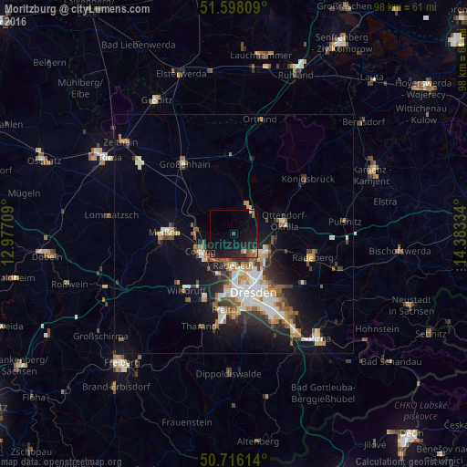
Analysis of Moritzburg night lights 2016
Square area 10x10 km:
 0.8%
0.8%90-99
0.27%80-89
0.53%70-79
0.53%60-69
1.07%50-59
3.21%40-49
1.6%30-39
0.27%20-29
6.15%10-19
23.13%0-9
62.43%Square area 50x50 km:
1.85%90-99
1.92%80-89
0.81%70-79
1.31%60-69
1.27%50-59
1.49%40-49
1.28%30-39
1.63%20-29
2.26%10-19
6.46%0-9
79.74%Clear (daylight) street map image can be seen on geolist.org.
Map coordinates:
51° 35' 53.1" North, 12° 58' 37.5" East
51° 9' 33.2" North, 13° 40' 48.8" East
50° 42' 58.1" North, 14° 23' 0" East
Some cities around Moritzburg sort by population:
• Dresden
12.7 km =7.9 mi,  161°
161°
• Radebeul
6 km =3.7 mi,  193°
193°
• Meissen
14.4 km =8.9 mi,  271°
271°
• Coswig
7.4 km =4.6 mi,  245°
245°
• Weinböhla
8 km =5 mi,  275°
275°
• Ottendorf-Okrilla
11 km =6.8 mi,  75°
75°
• Radeburg
7.1 km =4.4 mi,  28°
28°
• Ebersbach
8.5 km =5.3 mi,  345°
345°
2869244 (p: 8,085)
Sources (retrieved 2019-11-25):
» Earth at Night: Flat Maps 2012, 2016