Riegelsberg night lights from space
Night Light of Riegelsberg (Saarland) from space (Germany) Src. Average luminocity for 10x10km area is 21.4532% and for 50x50km: 20.0061%.
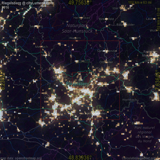
Analysis of Riegelsberg night lights 2016
Square area 10x10 km:
 0.53%
0.53%90-99
0.53%80-89
1.47%70-79
1.2%60-69
2.27%50-59
5.35%40-49
5.88%30-39
2.94%20-29
20.32%10-19
27.27%0-9
32.22%Square area 50x50 km:
3.07%90-99
3.22%80-89
1.42%70-79
1.82%60-69
2.3%50-59
2.82%40-49
3.05%30-39
3.65%20-29
8.68%10-19
17.98%0-9
51.99%Clear (daylight) street map image can be seen on geolist.org.
Map coordinates:
49° 45' 23" North, 6° 13' 48.8" East
49° 18' 0" North, 6° 55' 60" East
48° 50' 21.7" North, 7° 38' 11.3" East
Some cities around Riegelsberg sort by population:
• Saarbrücken
9.3 km =5.8 mi,  143°
143°
• Völklingen
7.6 km =4.7 mi,  225°
225°
• Püttlingen
3.7 km =2.3 mi,  244°
244°
• Heusweiler
4 km =2.5 mi,  356°
356°
• Schwalbach
8.5 km =5.3 mi,  270°
270°
• Sulzbach
9 km =5.6 mi,  90°
90°
• Quierschied
8.7 km =5.4 mi,  77°
77°
• Bous
9.9 km =6.2 mi,  255°
255°
2847033 (p: 15,647)
Sources (retrieved 2019-11-25):
» Earth at Night: Flat Maps 2012, 2016