Humboldtkolonie night lights from space
Night Light of Humboldtkolonie (North Rhine-Westphalia) from space (Germany) Src. Average luminocity for 10x10km area is 84.2941% and for 50x50km: 32.3471%.
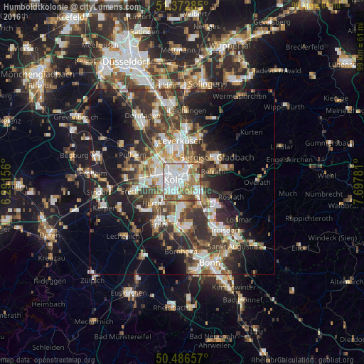
Analysis of Humboldtkolonie night lights 2016
Square area 10x10 km:
 33.61%
90-99
25.63%80-89
5.74%70-79
5.6%60-69
14.57%50-59
8.96%40-49
4.06%30-39
1.82%20-29
0%10-19
0%0-9
0%Square area 50x50 km:
6.05%90-99
6.55%80-89
2.98%70-79
3.12%60-69
4.3%50-59
4.67%40-49
4.7%30-39
7.1%20-29
9.03%10-19
14.57%0-9
36.91%Clear (daylight) street map image can be seen on geolist.org.
Map coordinates:
51° 22' 22.3" North, 6° 17' 29.6" East
50° 55' 54.6" North, 6° 59' 40.9" East
50° 29' 11.7" North, 7° 41' 52.1" East
Some cities around Humboldtkolonie sort by population:
• Altstadt Sud
2.5 km =1.6 mi,  273°
273°
• Kalk
1.2 km =0.7 mi,  40°
40°
• Altstadt Nord
2.7 km =1.7 mi,  286°
286°
• Deutz
1.4 km =0.9 mi,  282°
282°
• Buchheim
2.9 km =1.8 mi, 40°
• Poll
2.2 km =1.4 mi,  187°
187°
• Bayenthal
2.9 km =1.8 mi,  220°
220°
• Buchforst
2.3 km =1.4 mi,  20°
20°
2897732 (p: 15,108)
Sources (retrieved 2019-11-25):
» Earth at Night: Flat Maps 2012, 2016