Kraichtal night lights from space
Night Light of Kraichtal (Baden-Württemberg) from space (Germany) Src. Average luminocity for 10x10km area is 3.1933% and for 50x50km: 16.6461%.
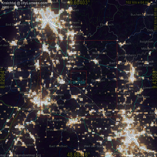
Analysis of Kraichtal night lights 2016
Square area 10x10 km:
 0%
0%90-99
0.28%80-89
0.28%70-79
0%60-69
0.56%50-59
0.56%40-49
0.56%30-39
0%20-29
1.26%10-19
0.98%0-9
95.52%Square area 50x50 km:
1.88%90-99
2.34%80-89
1.51%70-79
1.53%60-69
2.13%50-59
2.08%40-49
2.28%30-39
2.38%20-29
5.48%10-19
19.73%0-9
58.66%Clear (daylight) street map image can be seen on geolist.org.
Map coordinates:
49° 36' 14.5" North, 8° 1' 46.7" East
49° 8' 46.4" North, 8° 43' 57.9" East
48° 41' 3" North, 9° 26' 9.2" East
Some cities around Kraichtal sort by population:
• Bruchsal
10.1 km =6.3 mi,  256°
256°
• Bretten
12.3 km =7.6 mi,  188°
188°
• Östringen
8.2 km =5.1 mi,  349°
349°
• Ubstadt-Weiher
7.6 km =4.7 mi,  284°
284°
• Oberderdingen
10.3 km =6.4 mi,  150°
150°
• Mühlhausen
11.4 km =7.1 mi,  357°
357°
• Forst
11.1 km =6.9 mi, 277°
• Kronau
11.2 km =7 mi,  318°
318°
11670105 (p: 14,416)
Sources (retrieved 2019-11-25):
» Earth at Night: Flat Maps 2012, 2016