Kirchheim am Neckar night lights from space
Night Light of Kirchheim am Neckar (Baden-Württemberg) from space (Germany) Src. Average luminocity for 10x10km area is 18.0908% and for 50x50km: 17.8236%.
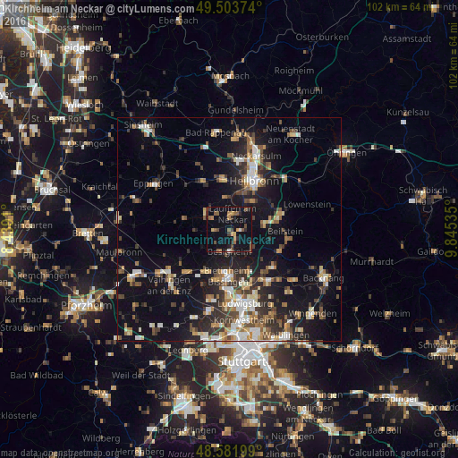
Analysis of Kirchheim am Neckar night lights 2016
Square area 10x10 km:
 0.45%
0.45%90-99
0.45%80-89
1.93%70-79
1.79%60-69
2.68%50-59
6.25%40-49
3.57%30-39
1.64%20-29
3.72%10-19
16.07%0-9
61.46%Square area 50x50 km:
2.19%90-99
2.72%80-89
1.62%70-79
1.95%60-69
2.43%50-59
2.52%40-49
2.75%30-39
2.99%20-29
4.96%10-19
13.12%0-9
62.74%Clear (daylight) street map image can be seen on geolist.org.
Map coordinates:
49° 30' 13.5" North, 8° 26' 20.8" East
49° 2' 42" North, 9° 8' 32" East
48° 34' 55.2" North, 9° 50' 43.3" East
Some cities around Kirchheim am Neckar sort by population:
• Brackenheim
6.6 km =4.1 mi,  303°
303°
• Besigheim
5.2 km =3.2 mi,  179°
179°
• Lauffen am Neckar
3.2 km =2 mi,  4°
4°
• Ilsfeld
7.7 km =4.8 mi,  81°
81°
• Bönnigheim
3.6 km =2.2 mi,  261°
261°
• Nordheim
7.2 km =4.5 mi,  351°
351°
• Flein
8.2 km =5.1 mi,  37°
37°
• Löchgau
5.3 km =3.3 mi,  209°
209°
2890482 (p: 5,193)
Sources (retrieved 2019-11-25):
» Earth at Night: Flat Maps 2012, 2016