Thalheim night lights from space
Night Light of Thalheim (Saxony) from space (Germany) Src. Average luminocity for 10x10km area is 3.1524% and for 50x50km: 7.642%.
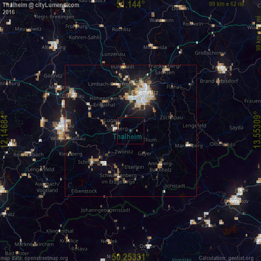
Analysis of Thalheim night lights 2016
Square area 10x10 km:
 0%
0%90-99
0%80-89
0.53%70-79
0%60-69
1.2%50-59
0.94%40-49
0.53%30-39
0%20-29
0%10-19
0.13%0-9
96.66%Square area 50x50 km:
0.97%90-99
1.28%80-89
0.84%70-79
0.67%60-69
1.07%50-59
1.2%40-49
0.91%30-39
0.8%20-29
2.14%10-19
4.97%0-9
85.15%Clear (daylight) street map image can be seen on geolist.org.
Map coordinates:
51° 8' 38.4" North, 12° 8' 48.6" East
50° 42' 2.8" North, 12° 50' 59.9" East
50° 15' 11.9" North, 13° 33' 11.1" East
Some cities around Thalheim sort by population:
• Stollberg
5 km =3.1 mi,  281°
281°
• Zwönitz
8.3 km =5.2 mi,  199°
199°
• Lugau
8.3 km =5.2 mi,  300°
300°
• Neukirchen
8.8 km =5.5 mi,  8°
8°
• Burkhardtsdorf
5.9 km =3.7 mi,  52°
52°
• Jahnsdorf
4.9 km =3 mi,  3°
3°
• Thum
7.9 km =4.9 mi,  115°
115°
• Ehrenfriedersdorf
10.2 km =6.3 mi, 124°
2823081 (p: 7,583)
Sources (retrieved 2019-11-25):
» Earth at Night: Flat Maps 2012, 2016