Nachrodt-Wiblingwerde night lights from space
Night Light of Nachrodt-Wiblingwerde (North Rhine-Westphalia) from space (Germany) Src. Average luminocity for 10x10km area is 6.8515% and for 50x50km: 17.3057%.
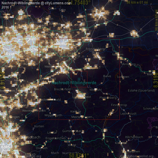
Analysis of Nachrodt-Wiblingwerde night lights 2016
Square area 10x10 km:
 0%
0%90-99
0.56%80-89
1.12%70-79
0.56%60-69
0%50-59
0.28%40-49
1.12%30-39
0.56%20-29
1.4%10-19
5.04%0-9
89.36%Square area 50x50 km:
2.21%90-99
2.59%80-89
1.62%70-79
2.17%60-69
2.63%50-59
2.96%40-49
2.98%30-39
2.87%20-29
4.25%10-19
11.96%0-9
63.75%Clear (daylight) street map image can be seen on geolist.org.
Map coordinates:
51° 45' 14.5" North, 6° 54' 48.8" East
51° 19' 0" North, 7° 37' 0" East
50° 52' 30.4" North, 8° 19' 11.3" East
Some cities around Nachrodt-Wiblingwerde sort by population:
• Hagen
11.2 km =7 mi,  295°
295°
• Iserlohn
8.9 km =5.5 mi,  42°
42°
• Lüdenscheid
10.8 km =6.7 mi,  176°
176°
• Altena
4.6 km =2.9 mi,  121°
121°
• Werdohl
12.1 km =7.5 mi, 121°
• Neuenrade
12.1 km =7.5 mi,  108°
108°
• Schalksmühle
10.4 km =6.5 mi,  216°
216°
• Breckerfeld
12.1 km =7.5 mi,  238°
238°
2867252 (p: 6,860)
Sources (retrieved 2019-11-25):
» Earth at Night: Flat Maps 2012, 2016