Schalksmühle night lights from space
Night Light of Schalksmühle (North Rhine-Westphalia) from space (Germany) Src. Average luminocity for 10x10km area is 5.4874% and for 50x50km: 14.3905%.
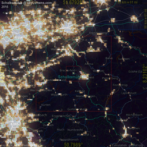
Analysis of Schalksmühle night lights 2016
Square area 10x10 km:
 0.56%
0.56%90-99
0.56%80-89
0%70-79
0.28%60-69
0.28%50-59
0%40-49
3.08%30-39
0.28%20-29
0.28%10-19
6.58%0-9
88.1%Square area 50x50 km:
1.35%90-99
1.82%80-89
1.26%70-79
1.81%60-69
2.37%50-59
2.08%40-49
2.57%30-39
2.39%20-29
5.24%10-19
12.83%0-9
66.27%Clear (daylight) street map image can be seen on geolist.org.
Map coordinates:
51° 40' 45.4" North, 6° 49' 29.2" East
51° 14' 28.3" North, 7° 31' 40.4" East
50° 47' 56" North, 8° 13' 51.7" East
Some cities around Schalksmühle sort by population:
• Lüdenscheid
7.3 km =4.5 mi,  108°
108°
• Ennepetal
13.1 km =8.1 mi,  299°
299°
• Radevormwald
12.5 km =7.8 mi,  249°
249°
• Altena
11.7 km =7.3 mi,  59°
59°
• Kierspe
12.7 km =7.9 mi,  159°
159°
• Halver
6.5 km =4 mi,  198°
198°
• Breckerfeld
4.6 km =2.9 mi, 295°
• Nachrodt-Wiblingwerde
10.4 km =6.5 mi,  36°
36°
2840555 (p: 11,753)
Sources (retrieved 2019-11-25):
» Earth at Night: Flat Maps 2012, 2016