Mülheim-Kärlich night lights from space
Night Light of Mülheim-Kärlich (Rheinland-Pfalz) from space (Germany) Src. Average luminocity for 10x10km area is 40.077% and for 50x50km: 8.1025%.
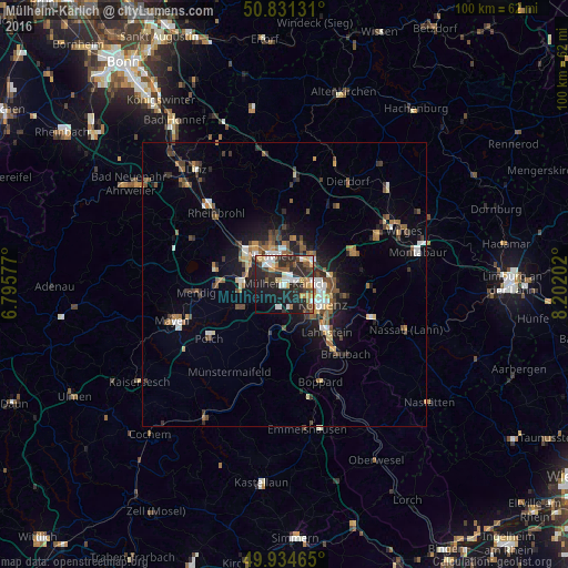
Analysis of Mülheim-Kärlich night lights 2016
Square area 10x10 km:
 6.02%
6.02%90-99
6.72%80-89
4.2%70-79
5.04%60-69
4.2%50-59
5.32%40-49
5.88%30-39
5.04%20-29
27.45%10-19
20.59%0-9
9.52%Square area 50x50 km:
0.87%90-99
1.04%80-89
0.69%70-79
0.69%60-69
1.31%50-59
1.39%40-49
1.55%30-39
1.28%20-29
2.55%10-19
4.82%0-9
83.82%Clear (daylight) street map image can be seen on geolist.org.
Map coordinates:
50° 49' 52.7" North, 6° 47' 44.8" East
50° 23' 6.4" North, 7° 29' 56" East
49° 56' 4.7" North, 8° 12' 7.3" East
Some cities around Mülheim-Kärlich sort by population:
• Koblenz
6.7 km =4.2 mi,  121°
121°
• Neuwied
5.8 km =3.6 mi,  339°
339°
• Andernach
8.4 km =5.2 mi,  307°
307°
• Bendorf
7.1 km =4.4 mi,  53°
53°
• Vallendar
9 km =5.6 mi,  82°
82°
• Weißenthurm
4.9 km =3 mi,  316°
316°
• Plaidt
7.6 km =4.7 mi,  276°
276°
• Ochtendung
9.1 km =5.7 mi,  244°
244°
3207806 (p: 10,451)
Sources (retrieved 2019-11-25):
» Earth at Night: Flat Maps 2012, 2016