Andernach night lights from space
Night Light of Andernach (Rheinland-Pfalz) from space (Germany) Src. Average luminocity for 10x10km area is 33% and for 50x50km: 8.1693%.
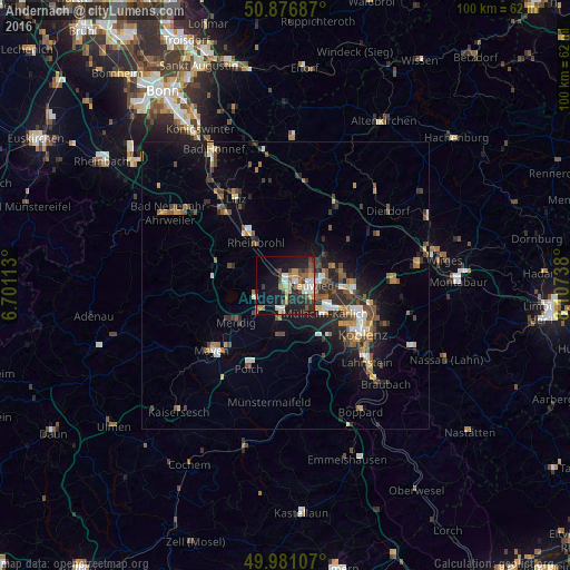

Analysis of Andernach night lights 2016
Square area 10x10 km:
 4.2%
4.2%90-99
5.18%80-89
3.78%70-79
4.06%60-69
6.58%50-59
3.36%40-49
6.72%30-39
3.64%20-29
9.66%10-19
26.47%0-9
26.33%Square area 50x50 km:
0.79%90-99
1.03%80-89
0.76%70-79
0.77%60-69
1.29%50-59
1.4%40-49
1.62%30-39
1.16%20-29
2.52%10-19
5.28%0-9
83.39%Clear (daylight) street map image can be seen on geolist.org.
Map coordinates:
50° 52' 36.7" North, 6° 42' 4.1" East
50° 25' 51.9" North, 7° 24' 15.3" East
49° 58' 51.9" North, 8° 6' 26.6" East
Some cities around Andernach sort by population:
• Neuwied
4.7 km =2.9 mi,  86°
86°
• Mülheim-Kärlich
8.4 km =5.2 mi,  127°
127°
• Bad Breisig
11.6 km =7.2 mi,  315°
315°
• Mendig
11.2 km =7 mi,  230°
230°
• Weißenthurm
3.6 km =2.2 mi,  115°
115°
• Plaidt
4.4 km =2.7 mi,  190°
190°
• Bad Hönningen
11.6 km =7.2 mi,  325°
325°
• Ochtendung
9.1 km =5.7 mi, 189°
2956206 (p: 29,599)
Sources (retrieved 2019-11-25):
» Earth at Night: Flat Maps 2012, 2016