Mücheln night lights from space
Night Light of Mücheln (Saxony-Anhalt) from space (Germany) Src. Average luminocity for 10x10km area is 1.5112% and for 50x50km: 6.8639%.
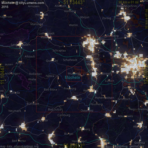
Analysis of Mücheln night lights 2016
Square area 10x10 km:
 0%
0%90-99
0%80-89
0%70-79
0%60-69
0.56%50-59
0%40-49
1.12%30-39
0%20-29
0.56%10-19
1.68%0-9
96.08%Square area 50x50 km:
1.23%90-99
1.48%80-89
0.62%70-79
0.47%60-69
0.67%50-59
0.62%40-49
0.76%30-39
0.82%20-29
2.04%10-19
5.09%0-9
86.18%Clear (daylight) street map image can be seen on geolist.org.
Map coordinates:
51° 44' 3.9" North, 11° 6' 16.1" East
51° 17' 48.8" North, 11° 48' 27.3" East
50° 51' 18.4" North, 12° 30' 38.6" East
Some cities around Mücheln sort by population:
• Merseburg
14.2 km =8.8 mi,  62°
62°
• Weißenfels
15.4 km =9.6 mi,  133°
133°
• Naumburg
16.3 km =10.1 mi,  179°
179°
• Querfurt
17.2 km =10.7 mi,  303°
303°
• Teutschenthal
17 km =10.6 mi,  358°
358°
• Leuna
14.7 km =9.1 mi,  80°
80°
• Braunsbedra
5.8 km =3.6 mi,  101°
101°
• Bad Lauchstädt
10.9 km =6.8 mi,  23°
23°
2868933 (p: 6,389)
Sources (retrieved 2019-11-25):
» Earth at Night: Flat Maps 2012, 2016