Braunsbedra night lights from space
Night Light of Braunsbedra (Saxony-Anhalt) from space (Germany) Src. Average luminocity for 10x10km area is 3.8501% and for 50x50km: 8.1955%.
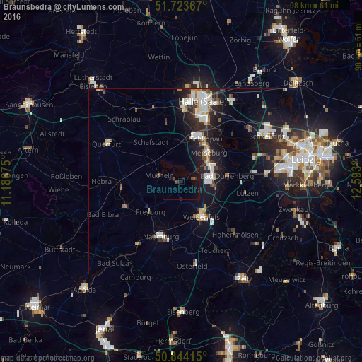
Analysis of Braunsbedra night lights 2016
Square area 10x10 km:
 0%
0%90-99
0%80-89
0%70-79
0%60-69
0%50-59
0.56%40-49
1.68%30-39
0.56%20-29
1.4%10-19
7.14%0-9
88.66%Square area 50x50 km:
1.53%90-99
1.81%80-89
0.7%70-79
0.53%60-69
0.73%50-59
0.7%40-49
0.83%30-39
0.92%20-29
2.38%10-19
6.74%0-9
83.13%Clear (daylight) street map image can be seen on geolist.org.
Map coordinates:
51° 43' 25.2" North, 11° 11' 12.3" East
51° 17' 9.7" North, 11° 53' 23.5" East
50° 50' 38.9" North, 12° 35' 34.8" East
Some cities around Braunsbedra sort by population:
• Merseburg
10.3 km =6.4 mi,  42°
42°
• Weißenfels
10.9 km =6.8 mi,  149°
149°
• Naumburg
16.1 km =10 mi,  200°
200°
• Bad Dürrenberg
12.3 km =7.6 mi,  85°
85°
• Teutschenthal
19.3 km =12 mi,  341°
341°
• Leuna
9.4 km =5.8 mi,  68°
68°
• Mücheln
5.8 km =3.6 mi,  281°
281°
• Bad Lauchstädt
11.3 km =7 mi,  352°
352°
2945041 (p: 6,599)
Sources (retrieved 2019-11-25):
» Earth at Night: Flat Maps 2012, 2016