Bad Lauchstädt night lights from space
Night Light of Bad Lauchstädt (Saxony-Anhalt) from space (Germany) Src. Average luminocity for 10x10km area is 5.402% and for 50x50km: 8.0424%.
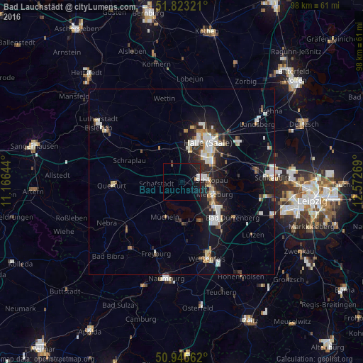
Analysis of Bad Lauchstädt night lights 2016
Square area 10x10 km:
 1.4%
1.4%90-99
0.28%80-89
0%70-79
0.56%60-69
0%50-59
0.28%40-49
0.28%30-39
0%20-29
1.54%10-19
10.64%0-9
85.01%Square area 50x50 km:
1.47%90-99
1.79%80-89
0.64%70-79
0.54%60-69
0.71%50-59
0.67%40-49
0.86%30-39
0.79%20-29
2.27%10-19
7.08%0-9
83.19%Clear (daylight) street map image can be seen on geolist.org.
Map coordinates:
51° 49' 23.6" North, 11° 9' 59.2" East
51° 23' 11.5" North, 11° 52' 10.4" East
50° 56' 44.2" North, 12° 34' 21.7" East
Some cities around Bad Lauchstädt sort by population:
• Halle (Saale)
13 km =8.1 mi,  35°
35°
• Halle Neustadt
10.8 km =6.7 mi,  17°
17°
• Merseburg
9 km =5.6 mi,  113°
113°
• Bad Dürrenberg
17 km =10.6 mi,  126°
126°
• Teutschenthal
8.5 km =5.3 mi,  325°
325°
• Leuna
12.7 km =7.9 mi, 126°
• Braunsbedra
11.3 km =7 mi,  172°
172°
• Mücheln
10.9 km =6.8 mi,  203°
203°
2953412 (p: 5,018)
Sources (retrieved 2019-11-25):
» Earth at Night: Flat Maps 2012, 2016