Leuna night lights from space
Night Light of Leuna (Saxony-Anhalt) from space (Germany) Src. Average luminocity for 10x10km area is 30.5938% and for 50x50km: 12.8743%.
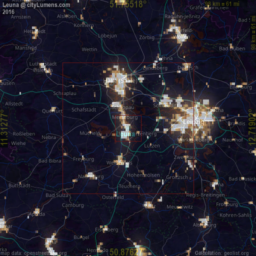
Analysis of Leuna night lights 2016
Square area 10x10 km:
 7.84%
7.84%90-99
6.02%80-89
2.1%70-79
2.1%60-69
3.5%50-59
1.4%40-49
3.36%30-39
3.22%20-29
7%10-19
36.27%0-9
27.17%Square area 50x50 km:
2.47%90-99
2.83%80-89
1.05%70-79
1.02%60-69
1.23%50-59
1.04%40-49
1.37%30-39
1.93%20-29
4.13%10-19
9.18%0-9
73.73%Clear (daylight) street map image can be seen on geolist.org.
Map coordinates:
51° 45' 18.6" North, 11° 18' 46" East
51° 19' 4.2" North, 12° 0' 57.2" East
50° 52' 34.6" North, 12° 43' 8.5" East
Some cities around Leuna sort by population:
• Merseburg
4.5 km =2.8 mi,  335°
335°
• Weißenfels
13.4 km =8.3 mi,  194°
194°
• Schkeuditz
16.8 km =10.4 mi,  58°
58°
• Markranstädt
14.3 km =8.9 mi,  97°
97°
• Bad Dürrenberg
4.3 km =2.7 mi,  125°
125°
• Braunsbedra
9.4 km =5.8 mi,  248°
248°
• Mücheln
14.7 km =9.1 mi,  260°
260°
• Bad Lauchstädt
12.7 km =7.9 mi,  306°
306°
2878350 (p: 6,929)
Sources (retrieved 2019-11-25):
» Earth at Night: Flat Maps 2012, 2016