Teutschenthal night lights from space
Night Light of Teutschenthal (Saxony-Anhalt) from space (Germany) Src. Average luminocity for 10x10km area is 1.3877% and for 50x50km: 6.526%.
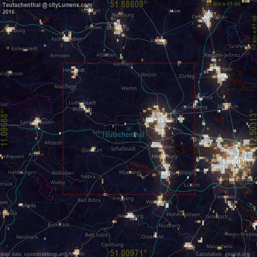
Analysis of Teutschenthal night lights 2016
Square area 10x10 km:
 0%
0%90-99
0%80-89
0%70-79
0%60-69
0.53%50-59
0.27%40-49
0.27%30-39
0.53%20-29
0%10-19
0%0-9
98.4%Square area 50x50 km:
1.15%90-99
1.48%80-89
0.49%70-79
0.44%60-69
0.66%50-59
0.59%40-49
0.65%30-39
0.7%20-29
2.11%10-19
5.4%0-9
86.33%Clear (daylight) street map image can be seen on geolist.org.
Map coordinates:
51° 53' 9.9" North, 11° 5' 48.8" East
51° 27' 0" North, 11° 48' 0" East
51° 0' 35" North, 12° 30' 11.3" East
Some cities around Teutschenthal sort by population:
• Halle (Saale)
12.9 km =8 mi,  74°
74°
• Halle Neustadt
8.7 km =5.4 mi, 67°
• Merseburg
16.9 km =10.5 mi,  128°
128°
• Eisleben Lutherstadt
19.4 km =12.1 mi,  296°
296°
• Querfurt
15.8 km =9.8 mi,  241°
241°
• Braunsbedra
19.3 km =12 mi,  161°
161°
• Mücheln
17 km =10.6 mi,  178°
178°
• Bad Lauchstädt
8.5 km =5.3 mi,  145°
145°
2823230 (p: 6,996)
Sources (retrieved 2019-11-25):
» Earth at Night: Flat Maps 2012, 2016