Kraslice night lights from space
Night Light of Kraslice (Karlovarský kraj) from space (Czech Republic) Src. Average luminocity for 10x10km area is 2.7311% and for 50x50km: 3.9138%.
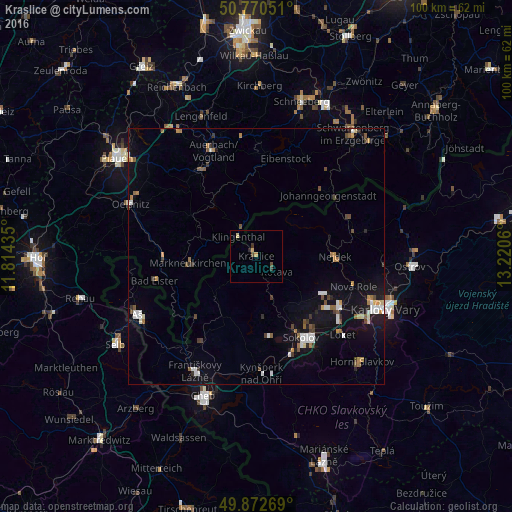
Analysis of Kraslice night lights 2016
Square area 10x10 km:
 0%
0%90-99
0%80-89
1.12%70-79
0.56%60-69
0%50-59
0%40-49
1.12%30-39
1.12%20-29
0.56%10-19
0%0-9
95.52%Square area 50x50 km:
0.57%90-99
0.64%80-89
0.21%70-79
0.44%60-69
0.41%50-59
0.44%40-49
0.55%30-39
0.54%20-29
0.43%10-19
2.9%0-9
92.85%Clear (daylight) street map image can be seen on geolist.org.
Map coordinates:
50° 46' 13.8" North, 11° 48' 51.7" East
50° 19' 25.4" North, 12° 31' 2.9" East
49° 52' 21.7" North, 13° 13' 14.2" East
Some cities around Kraslice sort by population:
• Sokolov
18.1 km =11.2 mi,  151°
151°
• Chodov
18.7 km =11.6 mi,  119°
119°
• Klingenthal, DE
5.5 km =3.4 mi,  316°
316°
• Nejdek
15 km =9.3 mi,  90°
90°
• Markneukirchen, DE
13.4 km =8.3 mi,  264°
264°
• Adorf, DE
18.3 km =11.4 mi,  268°
268°
• Johanngeorgenstadt, DE
18.3 km =11.4 mi,  48°
48°
• Habartov
15.8 km =9.8 mi,  171°
171°
3072903 (p: 7,159)
Sources (retrieved 2019-11-25):
» Earth at Night: Flat Maps 2012, 2016