Habartov night lights from space
Night Light of Habartov (Karlovarský kraj) from space (Czech Republic) Src. Average luminocity for 10x10km area is 4.0388% and for 50x50km: 4.1818%.
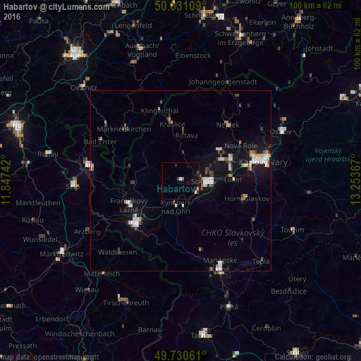
Analysis of Habartov night lights 2016
Square area 10x10 km:
 0.53%
0.53%90-99
0.53%80-89
0%70-79
0.53%60-69
0%50-59
0.53%40-49
0.53%30-39
1.07%20-29
1.07%10-19
1.6%0-9
93.58%Square area 50x50 km:
0.83%90-99
0.78%80-89
0.22%70-79
0.35%60-69
0.37%50-59
0.35%40-49
0.5%30-39
0.55%20-29
0.42%10-19
3.3%0-9
92.33%Clear (daylight) street map image can be seen on geolist.org.
Map coordinates:
50° 37' 51.9" North, 11° 50' 50.7" East
50° 10' 58.7" North, 12° 33' 1.9" East
49° 43' 50.2" North, 13° 15' 13.2" East
Some cities around Habartov sort by population:
• Cheb
17 km =10.6 mi,  227°
227°
• Sokolov
6.4 km =4 mi,  91°
91°
• Chodov
15.3 km =9.5 mi,  65°
65°
• Nejdek
20.1 km =12.5 mi,  39°
39°
• Kraslice
15.8 km =9.8 mi,  351°
351°
• Horní Slavkov
19 km =11.8 mi,  105°
105°
• Františkovy Lázně
15.8 km =9.8 mi,  243°
243°
• Kynšperk nad Ohří
7.3 km =4.5 mi,  191°
191°
3076076 (p: 5,337)
Sources (retrieved 2019-11-25):
» Earth at Night: Flat Maps 2012, 2016