Ottersweier night lights from space
Night Light of Ottersweier (Baden-Württemberg) from space (Germany) Src. Average luminocity for 10x10km area is 16.6176% and for 50x50km: 13.3729%.
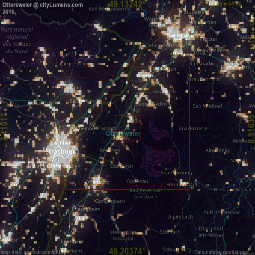
Analysis of Ottersweier night lights 2016
Square area 10x10 km:
 1.19%
1.19%90-99
2.38%80-89
1.93%70-79
2.08%60-69
2.68%50-59
1.93%40-49
1.93%30-39
2.38%20-29
4.32%10-19
6.7%0-9
72.47%Square area 50x50 km:
2.05%90-99
2.13%80-89
1.19%70-79
1.4%60-69
1.36%50-59
1.48%40-49
1.53%30-39
1.73%20-29
2.97%10-19
13.9%0-9
70.27%Clear (daylight) street map image can be seen on geolist.org.
Map coordinates:
49° 7' 56.7" North, 7° 24' 36.4" East
48° 40' 12.8" North, 8° 6' 47.6" East
48° 12' 13.5" North, 8° 48' 58.9" East
Some cities around Ottersweier sort by population:
• Bühl
3.4 km =2.1 mi,  28°
28°
• Achern
5.1 km =3.2 mi,  212°
212°
• Sinzheim
11.4 km =7.1 mi,  20°
20°
• Bühlertal
5.8 km =3.6 mi,  72°
72°
• Zell
4.4 km =2.7 mi,  303°
303°
• Kappelrodeck
8.7 km =5.4 mi,  178°
178°
• Sasbach
3.7 km =2.3 mi,  202°
202°
• Lichtenau
10.1 km =6.3 mi,  307°
307°
2855984 (p: 6,441)
Sources (retrieved 2019-11-25):
» Earth at Night: Flat Maps 2012, 2016