Besigheim night lights from space
Night Light of Besigheim (Baden-Württemberg) from space (Germany) Src. Average luminocity for 10x10km area is 21.5149% and for 50x50km: 21.1992%.
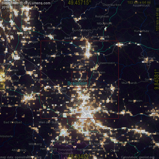
Analysis of Besigheim night lights 2016
Square area 10x10 km:
 1.64%
1.64%90-99
0.74%80-89
1.64%70-79
2.83%60-69
2.38%50-59
4.02%40-49
4.02%30-39
1.49%20-29
9.08%10-19
37.8%0-9
34.38%Square area 50x50 km:
3.42%90-99
3.76%80-89
1.8%70-79
2.13%60-69
2.66%50-59
2.74%40-49
3.13%30-39
3.45%20-29
5.88%10-19
14.14%0-9
56.9%Clear (daylight) street map image can be seen on geolist.org.
Map coordinates:
49° 27' 25.7" North, 8° 26' 22.4" East
48° 59' 52.7" North, 9° 8' 33.6" East
48° 32' 4.3" North, 9° 50' 44.9" East
Some cities around Besigheim sort by population:
• Bietigheim-Bissingen
6.3 km =3.9 mi,  197°
197°
• Sachsenheim
7.1 km =4.4 mi,  233°
233°
• Freiberg am Neckar
8.5 km =5.3 mi,  149°
149°
• Lauffen am Neckar
8.4 km =5.2 mi,  1°
1°
• Bönnigheim
5.9 km =3.7 mi,  322°
322°
• Pleidelsheim
6.2 km =3.9 mi,  134°
134°
• Löchgau
2.7 km =1.7 mi,  283°
283°
• Kirchheim am Neckar
5.2 km =3.2 mi,  359°
359°
2949803 (p: 11,883)
Sources (retrieved 2019-11-25):
» Earth at Night: Flat Maps 2012, 2016