Kall night lights from space
Night Light of Kall (North Rhine-Westphalia) from space (Germany) Src. Average luminocity for 10x10km area is 0.1631% and for 50x50km: 2.1821%.
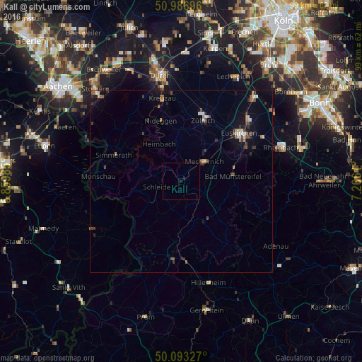
Analysis of Kall night lights 2016
Square area 10x10 km:
 0%
0%90-99
0%80-89
0%70-79
0%60-69
0%50-59
0%40-49
0%30-39
0%20-29
0%10-19
0.8%0-9
99.2%Square area 50x50 km:
0.2%90-99
0.27%80-89
0.15%70-79
0.14%60-69
0.33%50-59
0.36%40-49
0.34%30-39
0.43%20-29
0.46%10-19
1.32%0-9
96%Clear (daylight) street map image can be seen on geolist.org.
Map coordinates:
50° 59' 13.1" North, 5° 51' 35.5" East
50° 32' 32" North, 6° 33' 46.7" East
50° 5' 35.8" North, 7° 15' 58" East
Some cities around Kall sort by population:
• Mechernich
8.5 km =5.3 mi,  48°
48°
• Zulpich
18.1 km =11.2 mi,  20°
20°
• Bad Münstereifel
14.3 km =8.9 mi,  83°
83°
• Schleiden
6.3 km =3.9 mi,  256°
256°
• Nideggen
17.6 km =10.9 mi,  341°
341°
• Blankenheim
13.6 km =8.5 mi,  153°
153°
• Hellenthal
11.3 km =7 mi,  234°
234°
• Nettersheim
7.1 km =4.4 mi,  139°
139°
2893762 (p: 11,903)
Sources (retrieved 2019-11-25):
» Earth at Night: Flat Maps 2012, 2016