Blankenheim night lights from space
Night Light of Blankenheim (North Rhine-Westphalia) from space (Germany) Src. Average luminocity for 10x10km area is 0.3824% and for 50x50km: 1.2597%.
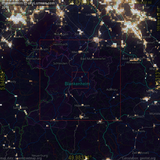
Analysis of Blankenheim night lights 2016
Square area 10x10 km:
 0%
0%90-99
0%80-89
0%70-79
0%60-69
0%50-59
0%40-49
0.56%30-39
0%20-29
0.14%10-19
0.42%0-9
98.88%Square area 50x50 km:
0.08%90-99
0.16%80-89
0.1%70-79
0.1%60-69
0.24%50-59
0.25%40-49
0.19%30-39
0.3%20-29
0.23%10-19
0.67%0-9
97.69%Clear (daylight) street map image can be seen on geolist.org.
Map coordinates:
50° 52' 44.7" North, 5° 56' 48.8" East
50° 25' 60" North, 6° 39' 0" East
49° 59' 0" North, 7° 21' 11.3" East
Some cities around Blankenheim sort by population:
• Euskirchen
27.1 km =16.8 mi,  20°
20°
• Mechernich
17.8 km =11.1 mi,  0°
0°
• Bad Münstereifel
15.9 km =9.9 mi,  30°
30°
• Schleiden
16.2 km =10.1 mi,  310°
310°
• Kall
13.6 km =8.5 mi,  333°
333°
• Hellenthal
16.3 km =10.1 mi,  289°
289°
• Nettersheim
6.9 km =4.3 mi,  347°
347°
• Gerolstein
23.5 km =14.6 mi,  178°
178°
2948056 (p: 8,770)
Sources (retrieved 2019-11-25):
» Earth at Night: Flat Maps 2012, 2016