Helmbrechts night lights from space
Night Light of Helmbrechts (Bavaria) from space (Germany) Src. Average luminocity for 10x10km area is 3.5949% and for 50x50km: 2.0453%.
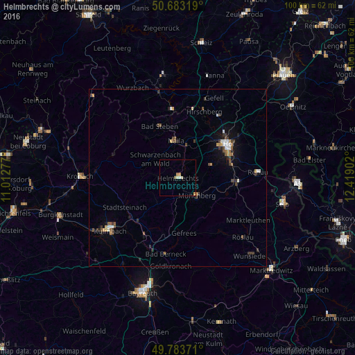
Analysis of Helmbrechts night lights 2016
Square area 10x10 km:
 0.4%
0.4%90-99
0.13%80-89
1.2%70-79
1.07%60-69
0.4%50-59
0.53%40-49
0%30-39
0%20-29
0%10-19
0%0-9
96.26%Square area 50x50 km:
0.2%90-99
0.27%80-89
0.16%70-79
0.3%60-69
0.14%50-59
0.34%40-49
0.45%30-39
0.52%20-29
0.21%10-19
0.95%0-9
96.45%Clear (daylight) street map image can be seen on geolist.org.
Map coordinates:
50° 40' 59.5" North, 11° 0' 46" East
50° 14' 8.1" North, 11° 42' 57.2" East
49° 47' 1.4" North, 12° 25' 8.5" East
Some cities around Helmbrechts sort by population:
• Hof
16.4 km =10.2 mi,  58°
58°
• Kulmbach
24.1 km =15 mi,  231°
231°
• Münchberg
7.3 km =4.5 mi,  134°
134°
• Schwarzenbach an der Saale
15.7 km =9.8 mi,  95°
95°
• Rehau
22.7 km =14.1 mi,  86°
86°
• Naila
10.6 km =6.6 mi,  355°
355°
• Bad Lobenstein
24.7 km =15.3 mi,  347°
347°
• Oberkotzau
15.8 km =9.8 mi,  79°
79°
2906744 (p: 9,493)
Sources (retrieved 2019-11-25):
» Earth at Night: Flat Maps 2012, 2016