Konradshöhe night lights from space
Night Light of Konradshöhe (Berlin) from space (Germany) Src. Average luminocity for 10x10km area is 47.4524% and for 50x50km: 33.8175%.
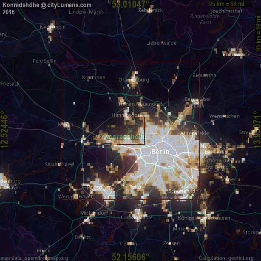
Analysis of Konradshöhe night lights 2016
Square area 10x10 km:
 8.33%
8.33%90-99
8.86%80-89
2.91%70-79
5.69%60-69
6.22%50-59
7.54%40-49
9.13%30-39
10.45%20-29
24.74%10-19
14.42%0-9
1.72%Square area 50x50 km:
10.57%90-99
8.86%80-89
3.37%70-79
2.66%60-69
2.93%50-59
3%40-49
3.21%30-39
3.74%20-29
6.27%10-19
8.96%0-9
46.42%Clear (daylight) street map image can be seen on geolist.org.
Map coordinates:
53° 0' 37.7" North, 12° 31' 28.1" East
52° 35' 7.3" North, 13° 13' 39.3" East
52° 9' 21.8" North, 13° 55' 50.6" East
Some cities around Konradshöhe sort by population:
• Falkenhagener Feld
5.5 km =3.4 mi,  227°
227°
• Spandau
4.3 km =2.7 mi,  206°
206°
• Tegel
4.6 km =2.9 mi,  103°
103°
• Hakenfelde
3.2 km =2 mi,  203°
203°
• Hennigsdorf
5.8 km =3.6 mi,  344°
344°
• Heiligensee
3.4 km =2.1 mi,  19°
19°
• Haselhorst
4.6 km =2.9 mi,  171°
171°
• Siemensstadt
5.5 km =3.4 mi,  154°
154°
2885689 (p: 5,939)
Sources (retrieved 2019-11-25):
» Earth at Night: Flat Maps 2012, 2016