Reichelsheim night lights from space
Night Light of Reichelsheim (Hesse) from space (Germany) Src. Average luminocity for 10x10km area is 0.123% and for 50x50km: 9.6628%.
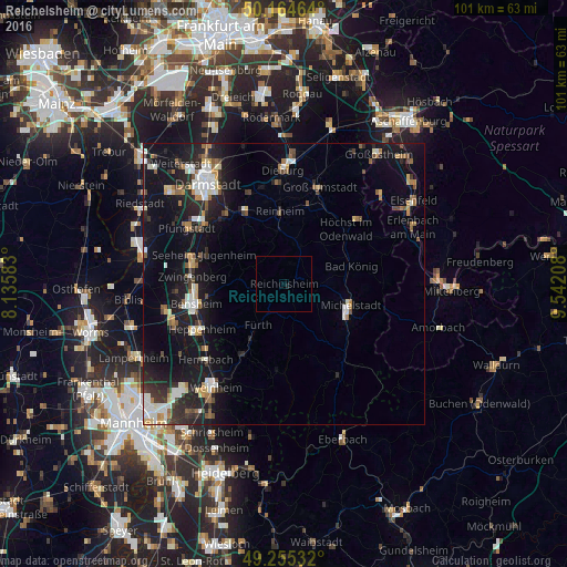
Analysis of Reichelsheim night lights 2016
Square area 10x10 km:
 0%
0%90-99
0%80-89
0%70-79
0%60-69
0%50-59
0%40-49
0%30-39
0%20-29
0.53%10-19
0%0-9
99.47%Square area 50x50 km:
1.4%90-99
1.69%80-89
0.73%70-79
0.95%60-69
1.04%50-59
1.06%40-49
1.13%30-39
1.22%20-29
3.36%10-19
9.93%0-9
77.5%Clear (daylight) street map image can be seen on geolist.org.
Map coordinates:
50° 9' 52.7" North, 8° 8' 9" East
49° 42' 43.6" North, 8° 50' 20.3" East
49° 15' 19.2" North, 9° 32' 31.5" East
Some cities around Reichelsheim sort by population:
• Michelstadt
12.5 km =7.8 mi,  108°
108°
• Erbach
12.5 km =7.8 mi,  116°
116°
• Fürth
7.9 km =4.9 mi,  209°
209°
• Bad König
12.6 km =7.8 mi,  74°
74°
• Rimbach
11.1 km =6.9 mi, 209°
• Lützelbach
6.2 km =3.9 mi,  302°
302°
• Lindenfels
5.2 km =3.2 mi,  232°
232°
• Brensbach
7.6 km =4.7 mi,  25°
25°
2849198 (p: 9,036)
Sources (retrieved 2019-11-25):
» Earth at Night: Flat Maps 2012, 2016