Lützelbach night lights from space
Night Light of Lützelbach (Hesse) from space (Germany) Src. Average luminocity for 10x10km area is 0.016% and for 50x50km: 11.7344%.
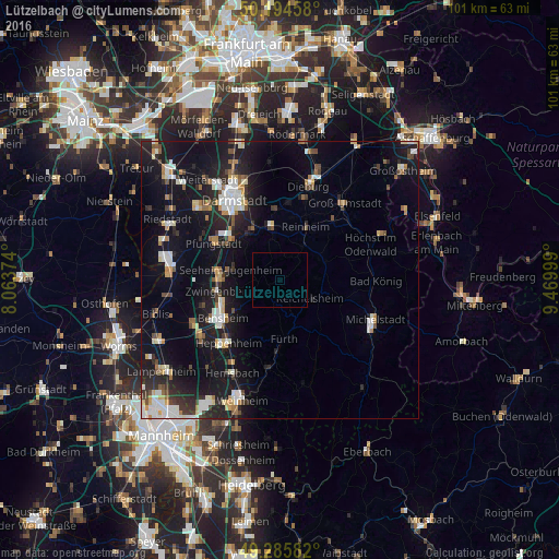
Analysis of Lützelbach night lights 2016
Square area 10x10 km:
 0%
0%90-99
0%80-89
0%70-79
0%60-69
0%50-59
0%40-49
0%30-39
0%20-29
0%10-19
0%0-9
100%Square area 50x50 km:
1.82%90-99
2.05%80-89
0.98%70-79
1.12%60-69
1.11%50-59
1.06%40-49
1.34%30-39
1.3%20-29
3.81%10-19
13.17%0-9
72.25%Clear (daylight) street map image can be seen on geolist.org.
Map coordinates:
50° 11' 40.5" North, 8° 3' 49.5" East
49° 44' 32.4" North, 8° 46' 0.7" East
49° 17' 9" North, 9° 28' 12" East
Some cities around Lützelbach sort by population:
• Reinheim
10.9 km =6.8 mi,  27°
27°
• Seeheim-Jugenheim
8.6 km =5.3 mi,  286°
286°
• Ober-Ramstadt
9.9 km =6.2 mi,  352°
352°
• Fürth
10.3 km =6.4 mi,  172°
172°
• Reichelsheim
6.2 km =3.9 mi,  122°
122°
• Lindenfels
6.6 km =4.1 mi, 170°
• Brensbach
9.1 km =5.7 mi,  67°
67°
• Bickenbach
10.9 km =6.8 mi,  279°
279°
2874768 (p: 7,321)
Sources (retrieved 2019-11-25):
» Earth at Night: Flat Maps 2012, 2016