Untergruppenbach night lights from space
Night Light of Untergruppenbach (Baden-Württemberg) from space (Germany) Src. Average luminocity for 10x10km area is 18.3319% and for 50x50km: 12.9675%.
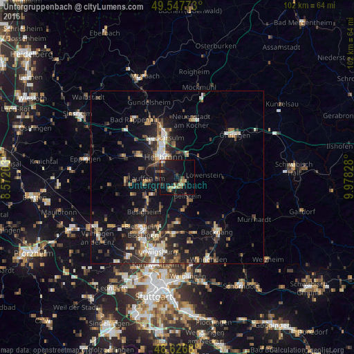
Analysis of Untergruppenbach night lights 2016
Square area 10x10 km:
 0.56%
0.56%90-99
1.26%80-89
2.24%70-79
3.36%60-69
1.82%50-59
3.08%40-49
2.1%30-39
2.24%20-29
5.18%10-19
29.13%0-9
49.02%Square area 50x50 km:
1.48%90-99
1.72%80-89
1.24%70-79
1.45%60-69
1.82%50-59
1.84%40-49
1.97%30-39
2.25%20-29
3.8%10-19
10.42%0-9
72.02%Clear (daylight) street map image can be seen on geolist.org.
Map coordinates:
49° 32' 51.8" North, 8° 34' 19.3" East
49° 5' 21.8" North, 9° 16' 30.6" East
48° 37' 36.5" North, 9° 58' 41.8" East
Some cities around Untergruppenbach sort by population:
• Heilbronn
6.9 km =4.3 mi,  324°
324°
• Weinsberg
6.9 km =4.3 mi,  7°
7°
• Lauffen am Neckar
9.6 km =6 mi,  259°
259°
• Großbottwar
9.9 km =6.2 mi,  172°
172°
• Ilsfeld
4.3 km =2.7 mi,  209°
209°
• Oberstenfeld
7.8 km =4.8 mi,  154°
154°
• Flein
4.9 km =3 mi,  287°
287°
• Beilstein
6 km =3.7 mi, 152°
2819479 (p: 7,567)
Sources (retrieved 2019-11-25):
» Earth at Night: Flat Maps 2012, 2016