Contwig night lights from space
Night Light of Contwig (Rheinland-Pfalz) from space (Germany) Src. Average luminocity for 10x10km area is 10.8676% and for 50x50km: 10.4014%.
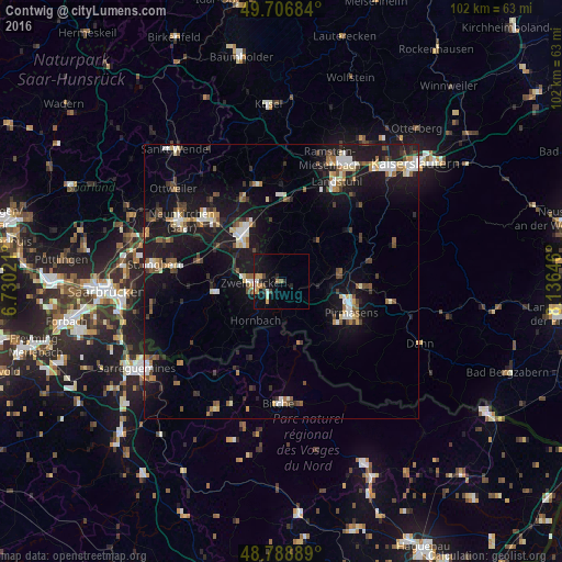
Analysis of Contwig night lights 2016
Square area 10x10 km:
 1.47%
1.47%90-99
0.67%80-89
1.07%70-79
2.81%60-69
1.87%50-59
0.13%40-49
1.47%30-39
0.67%20-29
2.14%10-19
12.83%0-9
74.87%Square area 50x50 km:
1.27%90-99
1.53%80-89
1.03%70-79
0.89%60-69
1.14%50-59
1.2%40-49
1.59%30-39
1.43%20-29
2.25%10-19
12.77%0-9
74.91%Clear (daylight) street map image can be seen on geolist.org.
Map coordinates:
49° 42' 24.6" North, 6° 43' 48.8" East
49° 15' 0" North, 7° 25' 60" East
48° 47' 20" North, 8° 8' 11.3" East
Some cities around Contwig sort by population:
• Homburg
10.9 km =6.8 mi,  321°
321°
• Pirmasens
13.6 km =8.5 mi,  113°
113°
• Zweibrücken
4.6 km =2.9 mi,  265°
265°
• Blieskastel
12.9 km =8 mi,  263°
263°
• Kirkel
15 km =9.3 mi,  284°
284°
• Bruchmühlbach-Miesau
14.8 km =9.2 mi,  0°
0°
• Rodalben
15 km =9.3 mi,  94°
94°
• Waldmohr
16.5 km =10.3 mi,  333°
333°
2939870 (p: 5,029)
Sources (retrieved 2019-11-25):
» Earth at Night: Flat Maps 2012, 2016