Bruchhausen-Vilsen night lights from space
Night Light of Bruchhausen-Vilsen (Lower Saxony) from space (Germany) Src. Average luminocity for 10x10km area is 0.7071% and for 50x50km: 2.671%.
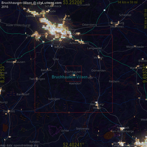
Analysis of Bruchhausen-Vilsen night lights 2016
Square area 10x10 km:
 0%
0%90-99
0%80-89
0%70-79
0.51%60-69
0.51%50-59
0%40-49
0%30-39
0%20-29
0%10-19
0%0-9
98.99%Square area 50x50 km:
0.29%90-99
0.37%80-89
0.18%70-79
0.33%60-69
0.4%50-59
0.34%40-49
0.51%30-39
0.35%20-29
1%10-19
2.22%0-9
94.01%Clear (daylight) street map image can be seen on geolist.org.
Map coordinates:
53° 15' 7.4" North, 8° 17' 15.1" East
52° 49' 45.5" North, 8° 59' 26.4" East
52° 24' 8.7" North, 9° 41' 37.6" East
Some cities around Bruchhausen-Vilsen sort by population:
• Achim
20.7 km =12.9 mi,  6°
6°
• Verden
19.4 km =12.1 mi,  57°
57°
• Syke
14.7 km =9.1 mi,  309°
309°
• Bassum
17.8 km =11.1 mi,  277°
277°
• Langwedel
21.1 km =13.1 mi,  38°
38°
• Sulingen
20.3 km =12.6 mi,  216°
216°
• Twistringen
23.7 km =14.7 mi,  261°
261°
• Dörverden
16.5 km =10.3 mi,  81°
81°
2943587 (p: 6,205)
Sources (retrieved 2019-11-25):
» Earth at Night: Flat Maps 2012, 2016