Breidenbach night lights from space
Night Light of Breidenbach (Hesse) from space (Germany) Src. Average luminocity for 10x10km area is 0.119% and for 50x50km: 1.6204%.
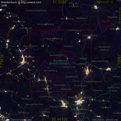
Analysis of Breidenbach night lights 2016
Square area 10x10 km:
 0%
0%90-99
0%80-89
0%70-79
0%60-69
0%50-59
0%40-49
0%30-39
0%20-29
0%10-19
0.56%0-9
99.44%Square area 50x50 km:
0.15%90-99
0.2%80-89
0.09%70-79
0.16%60-69
0.34%50-59
0.3%40-49
0.34%30-39
0.38%20-29
0.24%10-19
0.51%0-9
97.3%Clear (daylight) street map image can be seen on geolist.org.
Map coordinates:
51° 19' 43.7" North, 7° 45' 15.7" East
50° 53' 14.4" North, 8° 27' 26.9" East
50° 26' 30" North, 9° 9' 38.2" East
Some cities around Breidenbach sort by population:
• Bad Berleburg
18.9 km =11.7 mi,  346°
346°
• Bad Laasphe
5.4 km =3.4 mi,  335°
335°
• Biedenkopf
5.7 km =3.5 mi,  62°
62°
• Gladenbach
15.8 km =9.8 mi,  146°
146°
• Wetter
18.7 km =11.6 mi,  84°
84°
• Bad Endbach
15.6 km =9.7 mi,  168°
168°
• Erndtebrück
18.3 km =11.4 mi,  308°
308°
• Battenberg
19.3 km =12 mi,  43°
43°
2944820 (p: 6,866)
Sources (retrieved 2019-11-25):
» Earth at Night: Flat Maps 2012, 2016