Gerolstein night lights from space
Night Light of Gerolstein (Rheinland-Pfalz) from space (Germany) Src. Average luminocity for 10x10km area is 3.2433% and for 50x50km: 0.6828%.
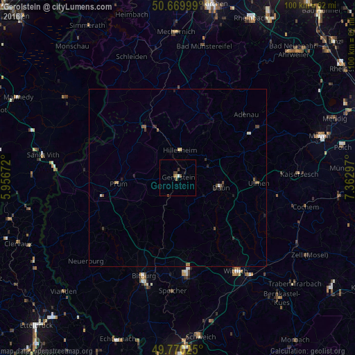
Analysis of Gerolstein night lights 2016
Square area 10x10 km:
 0.13%
0.13%90-99
0.4%80-89
0%70-79
0.53%60-69
1.07%50-59
0.67%40-49
0.8%30-39
0.94%20-29
0%10-19
0.53%0-9
94.92%Square area 50x50 km:
0.02%90-99
0.09%80-89
0.07%70-79
0.04%60-69
0.12%50-59
0.19%40-49
0.12%30-39
0.14%20-29
0.19%10-19
0.21%0-9
98.82%Clear (daylight) street map image can be seen on geolist.org.
Map coordinates:
50° 40' 12" North, 5° 57' 24.2" East
50° 13' 20.1" North, 6° 39' 35.4" East
49° 46' 12.9" North, 7° 21' 46.7" East
Some cities around Gerolstein sort by population:
• Wittlich
31.1 km =19.3 mi,  147°
147°
• Bitburg
29.8 km =18.5 mi,  198°
198°
• Blankenheim
23.5 km =14.6 mi,  358°
358°
• Hellenthal
33.2 km =20.6 mi,  331°
331°
• Daun
12.4 km =7.7 mi,  103°
103°
• Nettersheim
30.3 km =18.8 mi, 355°
• Prüm
17.1 km =10.6 mi,  264°
264°
• Bullange, BE
35.2 km =21.9 mi,  305°
305°
2920963 (p: 7,664)
Sources (retrieved 2019-11-25):
» Earth at Night: Flat Maps 2012, 2016