Bietigheim night lights from space
Night Light of Bietigheim (Baden-Württemberg) from space (Germany) Src. Average luminocity for 10x10km area is 23.9247% and for 50x50km: 15.5928%.
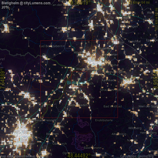
Analysis of Bietigheim night lights 2016
Square area 10x10 km:
 2.84%
2.84%90-99
2.27%80-89
0.99%70-79
2.98%60-69
1.85%50-59
5.26%40-49
4.26%30-39
3.69%20-29
3.13%10-19
42.61%0-9
30.11%Square area 50x50 km:
1.86%90-99
2.33%80-89
1.44%70-79
1.78%60-69
1.8%50-59
2.14%40-49
2.11%30-39
2.47%20-29
3.88%10-19
14.41%0-9
65.77%Clear (daylight) street map image can be seen on geolist.org.
Map coordinates:
49° 22' 9.1" North, 7° 32' 56" East
48° 54' 33.1" North, 8° 15' 7.3" East
48° 26' 41.7" North, 8° 57' 18.5" East
Some cities around Bietigheim sort by population:
• Rastatt
6.4 km =4 mi,  208°
208°
• Ettlingen
11.9 km =7.4 mi,  72°
72°
• Rheinstetten
7.7 km =4.8 mi,  31°
31°
• Malsch
6.6 km =4.1 mi,  115°
115°
• Durmersheim
2.9 km =1.8 mi,  21°
21°
• Rheinau
6.1 km =3.8 mi,  226°
226°
• Kuppenheim
9 km =5.6 mi,  179°
179°
• Muggensturm
5.3 km =3.3 mi,  154°
154°
2949014 (p: 6,026)
Sources (retrieved 2019-11-25):
» Earth at Night: Flat Maps 2012, 2016