Rheinau night lights from space
Night Light of Rheinau (Baden-Württemberg) from space (Germany) Src. Average luminocity for 10x10km area is 27.7358% and for 50x50km: 15.3739%.
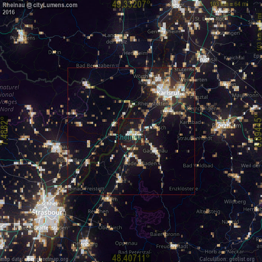
Analysis of Rheinau night lights 2016
Square area 10x10 km:
 3.84%
3.84%90-99
4.12%80-89
2.56%70-79
4.26%60-69
0.57%50-59
4.55%40-49
3.84%30-39
2.27%20-29
4.4%10-19
44.74%0-9
24.86%Square area 50x50 km:
1.86%90-99
2.31%80-89
1.46%70-79
1.74%60-69
1.69%50-59
2.1%40-49
2.21%30-39
2.4%20-29
3.61%10-19
14.44%0-9
66.17%Clear (daylight) street map image can be seen on geolist.org.
Map coordinates:
49° 19' 55.5" North, 7° 29' 17.5" East
48° 52' 18.2" North, 8° 11' 28.8" East
48° 24' 25.6" North, 8° 53' 40" East
Some cities around Rheinau sort by population:
• Baden-Baden
12.9 km =8 mi,  163°
163°
• Rastatt
2 km =1.2 mi,  137°
137°
• Malsch
10.5 km =6.5 mi,  82°
82°
• Durmersheim
8.8 km =5.5 mi,  38°
38°
• Sinzheim
11.8 km =7.3 mi,  188°
188°
• Kuppenheim
6.7 km =4.2 mi, 136°
• Muggensturm
6.8 km =4.2 mi,  94°
94°
• Bietigheim
6.1 km =3.8 mi,  46°
46°
2847669 (p: 10,976)
Sources (retrieved 2019-11-25):
» Earth at Night: Flat Maps 2012, 2016