Malsch night lights from space
Night Light of Malsch (Baden-Württemberg) from space (Germany) Src. Average luminocity for 10x10km area is 16.8352% and for 50x50km: 15.0216%.
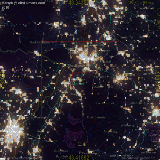
Analysis of Malsch night lights 2016
Square area 10x10 km:
 1.7%
1.7%90-99
1.99%80-89
0%70-79
1.85%60-69
2.84%50-59
1.99%40-49
0.71%30-39
1.99%20-29
2.13%10-19
39.77%0-9
45.03%Square area 50x50 km:
1.66%90-99
2.2%80-89
1.27%70-79
1.78%60-69
1.83%50-59
2.21%40-49
2.22%30-39
2.44%20-29
3.94%10-19
14.8%0-9
65.65%Clear (daylight) street map image can be seen on geolist.org.
Map coordinates:
49° 20' 36.9" North, 7° 37' 48.7" East
48° 52' 60" North, 8° 19' 60" East
48° 25' 7.8" North, 9° 2' 11.2" East
Some cities around Malsch sort by population:
• Rastatt
9.5 km =5.9 mi,  253°
253°
• Ettlingen
8.4 km =5.2 mi,  40°
40°
• Gaggenau
9.3 km =5.8 mi,  180°
180°
• Rheinstetten
9.7 km =6 mi,  348°
348°
• Durmersheim
7.4 km =4.6 mi,  318°
318°
• Kuppenheim
8.5 km =5.3 mi,  223°
223°
• Muggensturm
4.1 km =2.5 mi,  243°
243°
• Bietigheim
6.6 km =4.1 mi,  295°
295°
2874048 (p: 14,243)
Sources (retrieved 2019-11-25):
» Earth at Night: Flat Maps 2012, 2016