Pleidelsheim night lights from space
Night Light of Pleidelsheim (Baden-Württemberg) from space (Germany) Src. Average luminocity for 10x10km area is 37.7188% and for 50x50km: 22.8252%.
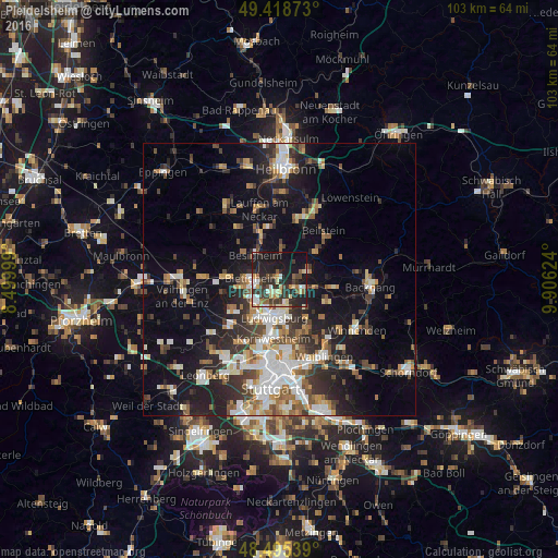
Analysis of Pleidelsheim night lights 2016
Square area 10x10 km:
 4.55%
4.55%90-99
5.26%80-89
6.96%70-79
2.27%60-69
3.98%50-59
5.4%40-49
4.83%30-39
9.94%20-29
18.89%10-19
30.26%0-9
7.67%Square area 50x50 km:
3.88%90-99
4.28%80-89
1.79%70-79
2.43%60-69
2.99%50-59
2.91%40-49
3.26%30-39
3.62%20-29
6.46%10-19
14.52%0-9
53.86%Clear (daylight) street map image can be seen on geolist.org.
Map coordinates:
49° 25' 7.4" North, 8° 29' 60" East
48° 57' 33.1" North, 9° 12' 11.2" East
48° 29' 43.4" North, 9° 54' 22.5" East
Some cities around Pleidelsheim sort by population:
• Ludwigsburg
6.9 km =4.3 mi,  186°
186°
• Bietigheim-Bissingen
6.5 km =4 mi,  254°
254°
• Marbach am Neckar
4.7 km =2.9 mi,  117°
117°
• Freiberg am Neckar
3 km =1.9 mi,  180°
180°
• Besigheim
6.2 km =3.9 mi,  314°
314°
• Steinheim am der Murr
5.5 km =3.4 mi,  79°
79°
• Murr
4.1 km =2.5 mi,  85°
85°
• Benningen am Neckar
3.2 km =2 mi, 115°
2853266 (p: 6,217)
Sources (retrieved 2019-11-25):
» Earth at Night: Flat Maps 2012, 2016