Sachsenheim night lights from space
Night Light of Sachsenheim (Baden-Württemberg) from space (Germany) Src. Average luminocity for 10x10km area is 21.8977% and for 50x50km: 23.9456%.
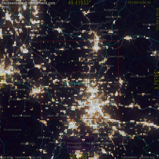
Analysis of Sachsenheim night lights 2016
Square area 10x10 km:
 1.99%
1.99%90-99
1.99%80-89
0.71%70-79
5.54%60-69
3.55%50-59
2.27%40-49
2.41%30-39
1.14%20-29
8.66%10-19
26.99%0-9
44.74%Square area 50x50 km:
3.89%90-99
4.42%80-89
2.03%70-79
2.5%60-69
3.18%50-59
3.03%40-49
3.29%30-39
3.71%20-29
6.5%10-19
16.53%0-9
50.91%Clear (daylight) street map image can be seen on geolist.org.
Map coordinates:
49° 25' 10.3" North, 8° 21' 41.8" East
48° 57' 36" North, 9° 3' 53" East
48° 29' 46.3" North, 9° 46' 4.3" East
Some cities around Sachsenheim sort by population:
• Bietigheim-Bissingen
4.2 km =2.6 mi,  114°
114°
• Vaihingen an der Enz
8.1 km =5 mi,  250°
250°
• Markgröningen
6.2 km =3.9 mi,  169°
169°
• Asperg
8 km =5 mi,  139°
139°
• Tamm
5.8 km =3.6 mi, 140°
• Besigheim
7.1 km =4.4 mi,  53°
53°
• Löchgau
5.7 km =3.5 mi,  32°
32°
• Sersheim
3.6 km =2.2 mi,  281°
281°
11951298 (p: 18,594)
Sources (retrieved 2019-11-25):
» Earth at Night: Flat Maps 2012, 2016