Freiberg am Neckar night lights from space
Night Light of Freiberg am Neckar (Baden-Württemberg) from space (Germany) Src. Average luminocity for 10x10km area is 53.9219% and for 50x50km: 24.6009%.
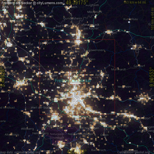
Analysis of Freiberg am Neckar night lights 2016
Square area 10x10 km:
 9.52%
9.52%90-99
14.49%80-89
8.95%70-79
3.13%60-69
5.97%50-59
5.97%40-49
4.55%30-39
10.8%20-29
23.3%10-19
13.07%0-9
0.28%Square area 50x50 km:
4.09%90-99
4.64%80-89
1.99%70-79
2.82%60-69
3.38%50-59
3.25%40-49
3.62%30-39
3.84%20-29
7%10-19
14.58%0-9
50.79%Clear (daylight) street map image can be seen on geolist.org.
Map coordinates:
49° 23' 30.3" North, 8° 29' 57.4" East
48° 55' 55.1" North, 9° 12' 8.6" East
48° 28' 4.4" North, 9° 54' 19.9" East
Some cities around Freiberg am Neckar sort by population:
• Ludwigsburg
3.9 km =2.4 mi,  191°
191°
• Bietigheim-Bissingen
6.3 km =3.9 mi,  282°
282°
• Marbach am Neckar
4.3 km =2.7 mi,  78°
78°
• Asperg
5.7 km =3.5 mi,  238°
238°
• Tamm
6.5 km =4 mi,  258°
258°
• Pleidelsheim
3 km =1.9 mi,  0°
0°
• Murr
5.3 km =3.3 mi,  51°
51°
• Benningen am Neckar
3.3 km =2.1 mi,  60°
60°
2925189 (p: 15,235)
Sources (retrieved 2019-11-25):
» Earth at Night: Flat Maps 2012, 2016